How Ground Penetrating Radar Works
Surface and Ground Penetrating Radar is a well-established non-destructive method of investigating the internal composition of many naturally occurring materials such as rocks, earth and gravels as well as man-made materials like brick, concrete and asphalt.
It can be used to detect metallic and non-metallic pipes, sewers, cables, cable ducts, voids, foundations, reinforcing in concrete and a whole host of other buried objects. It is also used to investigate the depth and make-up of different strata layers. A common use has been to scan areas of land before excavation takes place.
Principle of Operation
The radar system sends out pulses of electromagnetic (EM) energy and works by detecting the electrical echo caused when the pulse meets electromagnetic discontinuities, such as a pipe or void, within non-metallic structures and materials.
By moving the radar across the surface an image is created similar to that of a CT scan. The measured profile is termed a “time profile.” The depth is expressed in terms of Two Way Travel Time (TWTT) rather than true depth. TWTT is the time taken for the signal to leave the antenna transmitter, bounce off the target, and the reflected energy to return to the antenna receiver.
In the case of the 500 MHz antenna the radar sends out 1 ns long pulses at a repetition rate of 1 MHz. The Fourier transform of this pulse is approximately a sinx/x (sine cardinal) function, so the spectrum of the energy is spread over a wide band of frequencies.
In our 500 MHz antenna the distance between the transmit (Tx) and receive (Rx) antenna is approximately 215 mm. This is the first event the radar detects; no real information is seen before this. The only time Tx and Rx coincide is when they occupy the same point in space.
Frequencies, Resolution & Depth
With a standard antenna centered on 500 MHz, typical penetration depths of around two meters are obtained in the most common ground conditions and materials, with a corresponding resolution of typically 5 cm.
A 1 GHz antenna will resolve targets to a higher degree of resolution (less than 1 cm), but penetration is reduced to typically less than 75 cm.
Examples of expected performance:
- 500 MHz antenna in clean dry sand: depth penetration 12–15 feet
- 250 MHz antenna in clean dry sand: depth penetration to 40 feet
- 500 MHz antenna in dense wet clay: depth penetration 4–6 feet
- 250 MHz antenna in dense wet clay: depth penetration to 15 feet
Characteristics of the underlying soils affect penetration. Sands and gravels offer the best results with the greatest depth and clearest resolution. Dense saturated clays offer limited penetration. Site investigation prior to radar deployment is critical.
Materials That Can Be Penetrated
Sand, loam, chalk, sandstone, granite, etc. are all relatively easy to penetrate. The radar can also be used to see through fresh water and snow. Cured concrete and other hard layers can be penetrated depending on the number and spacing of any reinforcing rods present.
Worksmart uses a combination of commercial USRADAR systems (typically 250 MHz and 500 MHz antennas) and proprietary mounting platforms to deliver reliable data across a wide range of conditions.
Sample GPR Data
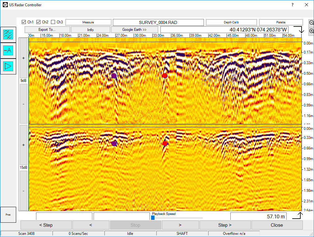
Its all about the data. You may have seen other companies radar data and all it looks like is a bunch random blobs. Look at these pictures. So crisp and clear you don't have to be an expert to see these anomalies...

This data depicts two anomalies with consistent characteristics to utilities. One is at a depth of 1.1 meters. The other 1.7 meters.

This data depicts an anomaly with consistent characteristics to a subsurface saturated soil area caused by a close proximity leak.

This data depicts an anomaly with consistent features to an under ground storage tank. This UST is under reinforced concrete.

This data also depicts an anomaly with consistent features to an under ground storage tank. This UST is also under reinforced concrete but at a much greater depth.

This data depicts several buried utilities in the same trench down to a depth of 1.2 meters.

This data depicts reinforcing bars in concrete as well as a small utility buried in the sub grade.

This GPR data depicts a utility, in this case a plastic pipe, as imaged without any filters. This is how it would appear using other brands of GPR.

In contrast, this is the same utility scan with a special filter we call "Remove Average". This filter allows our equipment and technicians to better view targets under metal reinforcing.
View Capabilities